Alfred Drowne Road Historic District
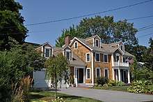
The Alfred Drowne Road Historic District of Barrington, Rhode Island, encompasses a suburban area developed between about 1860 and 1910, a period of significant suburban growth in Barrington spurred by the connection of the town by rail to Providence in 1855. This 27-acre (11 ha) residential area was before that time farmland owned by Alfred Drown, whose c. 1830 farmhouse still stands at 13 Alfred Drowne Road. The house of his son Benjamin, built c. 1856, is at number 27. The district includes properties along Alfred Drowne Road, as well as a few properties on Washington Street and Annawamscutt Road which are immediately adjacent.[2]
Alfred Drowne Road Historic District | |
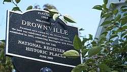 Plaque for Drowneville along Alfred Drowne Road | |
  | |
| Location | Barrington, Rhode Island |
|---|---|
| Coordinates | 41°44′31.10″N 71°20′38.60″W |
| Area | 27 acres (11 ha) |
| Built | 1855 |
| Architect | Mason, May |
| Architectural style | Greek Revival, Italianate |
| NRHP reference No. | 05000584 [1] |
| Added to NRHP | June 10, 2005 |
The district was listed on the National Register of Historic Places in 2005.[1]
See also
| Wikimedia Commons has media related to Alfred Drowne Road. |
References
- Michael P. McKinney, Wednesday, April 20, 2005, Providence Journal "Alfred Drowne Road nears OK for National Register"
- "National Register Information System". National Register of Historic Places. National Park Service. January 23, 2007.
- "NRHP nomination for Alfred Drowne Road Historic District" (PDF). RI Preservation. Retrieved 2014-06-08.
| Topics | |
|---|---|
| Lists by state |
|
| Lists by insular areas | |
| Lists by associated state | |
| Other areas | |
| Related | |
| |
This article is issued from Wikipedia. The text is licensed under Creative Commons - Attribution - Sharealike. Additional terms may apply for the media files.