Alabama State Route 295
State Route 295 (SR 295) is a 3.185-mile (5.126 km) state highway that serves the central areas of Grove Hill in central Clarke County. SR 295 intersects US 43 at both its southern and northern termini.
| ||||
|---|---|---|---|---|
| ||||
| Route information | ||||
| Maintained by ALDOT | ||||
| Length | 3.185 mi[1] (5.126 km) | |||
| Major junctions | ||||
| South end | ||||
| North end | ||||
| Location | ||||
| Counties | Clarke | |||
| Highway system | ||||
| ||||

Route description
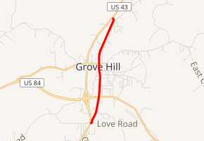
SR 295 begins at its intersection with US 43 just south of Grove Hill.[2] The route progresses in a northerly direction past the Grove Hill Memorial Hospital just prior to reaching its intersection with US 84.[3] SR 295 continues in its northerly track through the central business district of Grove Hill prior to intersecting US 43 at its northern terminus north of the town.[4]
History
The entire route of SR 295 is the former alignment of US 43 prior to the 4-Lane bypass being built to the west.
Major intersections
The entire route is in Grove Hill, Clarke County.
| mi[1] | km | Destinations | Notes | ||
|---|---|---|---|---|---|
| 0.000 | 0.000 | Southern terminus | |||
| 0.830 | 1.336 | Provides access to Grove Hill Municipal Airport | |||
| 3.185 | 5.126 | Northern terminus | |||
| 1.000 mi = 1.609 km; 1.000 km = 0.621 mi | |||||
gollark: I have that 30G Aeon (people here probably saw it before) which I could use...
gollark: That would be funny.
gollark: And xenowyrms and aeons.
gollark: On the other hand, I'd want to *use* the magic money tree it provides, so probably nebulae and coppers.
gollark: I'm pondering only breeding it with my stupidly messy dragons for the funlolz.
References
- Milepost Map of Clarke County (PDF) (Map). Cartography by ALDOT Bureau of Transportation Planning, Survey & Mapping Division. Alabama Department of Transportation. 1999. Archived from the original (PDF) on 2008-06-25.
- Google (April 29, 2010). "SR-295 southern terminus" (Map). Google Maps. Google. Retrieved April 29, 2010.
- Google (April 29, 2010). "SR-295 at US-84" (Map). Google Maps. Google. Retrieved April 29, 2010.
- Google (April 29, 2010). "SR-295 northern terminus" (Map). Google Maps. Google. Retrieved April 29, 2010.
External links
This article is issued from Wikipedia. The text is licensed under Creative Commons - Attribution - Sharealike. Additional terms may apply for the media files.