Alabama State Route 201
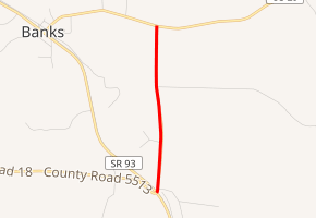
State Route 201 (SR 201) is a 1.553-mile (2.499 km) state highway in Pike County, Alabama, United States, that serves as an eastern bypass around the town of Banks.
| ||||
|---|---|---|---|---|

| ||||
| Route information | ||||
| Maintained by ALDOT | ||||
| Length | 1.553 mi[1] (2.499 km) | |||
| Major junctions | ||||
| South end | ||||
| North end | ||||
| Location | ||||
| Counties | Pike | |||
| Highway system | ||||
| ||||
Route description
The southern terminus of SR 201 is located at its intersection with SR 93 southeast of Banks. From this point, the route travels in a northerly direction before reaching its northern terminus at US 29 east of Banks.[2]
Major intersections
The entire route is in Pike County.
| Location | mi[1] | km | Destinations | Notes | |
|---|---|---|---|---|---|
| | 0.000 | 0.000 | Southern terminus | ||
| Banks | 1.553 | 2.499 | Northern terminus | ||
| 1.000 mi = 1.609 km; 1.000 km = 0.621 mi | |||||
gollark: Oh, I see, I can implement this I think.
gollark: ?????
gollark: Yes, characters only = mildly bees?
gollark: https://edu.casio.com/assets/images/products/cwiz/fx991ex/01/01.jpg
gollark: Calculators mildly improved in the past few years, so the random cheap ones almost everyone has for school here have somewhat high res monochrome graphical displays and can display expressions in a vaguely mathy-looking way.
See also
- List of state highways in Alabama
References
- Milepost Map of Pike County (PDF) (Map). Cartography by ALDOT Bureau of Transportation Planning, Survey & Mapping Division. Alabama Department of Transportation. 1999. Archived from the original (PDF) on 2008-06-25.
- Google (May 5, 2010). "SR-201 Full Route" (Map). Google Maps. Google. Retrieved May 5, 2010.
This article is issued from Wikipedia. The text is licensed under Creative Commons - Attribution - Sharealike. Additional terms may apply for the media files.
