Alabama State Route 198
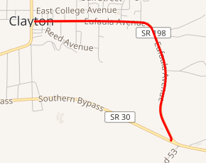
State Route 198 (SR 198) is a 1.686-mile-long (2.713 km) route that serves as a connection between SR 30 and SR 239 in Clayton.
| ||||
|---|---|---|---|---|
| Eufaula Avenue | ||||

| ||||
| Route information | ||||
| Maintained by ALDOT | ||||
| Length | 1.686 mi[1] (2.713 km) | |||
| Major junctions | ||||
| West end | ||||
| East end | ||||
| Location | ||||
| Counties | Barbour | |||
| Highway system | ||||
| ||||
Route description
The western terminus of SR 198 is located at its intersection with SR 239 (S/N Midway Street) in downtown Clayton. From this point, the route travels in an easterly direction before turning to the south en route to its eastern terminus at SR 30 (Southern Bypass). It is known as Eufaula Avenue for its entire length.[2]
Major intersections
The entire route is in Barbour County.
| Location | mi[1] | km | Destinations | Notes | |
|---|---|---|---|---|---|
| Clayton | 0.0 | 0.0 | Western terminus | ||
| 1.686 | 2.713 | Eastern terminus | |||
| 1.000 mi = 1.609 km; 1.000 km = 0.621 mi | |||||
gollark: Create... Macron?
gollark: As planned.
gollark: I have not learned to whistle because thing.
gollark: Just... use... SQLite?
gollark: I checked, and it seems like I am actually not doing that and cheating, oops.
References
- Milepost Map of Barbour County (PDF) (Map). Cartography by ALDOT Bureau of Transportation Planning, Survey & Mapping Division. Alabama Department of Transportation. 1999. Archived from the original (PDF) on 2008-06-25.
- Google (July 25, 2016). "Alabama State Route 198" (Map). Google Maps. Google. Retrieved July 25, 2016.
External links
This article is issued from Wikipedia. The text is licensed under Creative Commons - Attribution - Sharealike. Additional terms may apply for the media files.
