Alabama State Route 131
State Route 131 (SR 131) is a 27-mile-long (43 km) east–west state highway located entirely within Barbour County, Alabama. The route serves as the main road in Bakerhill.
| ||||
|---|---|---|---|---|
| ||||
| Route information | ||||
| Maintained by ALDOT | ||||
| Length | 27.124 mi[1] (43.652 km) | |||
| Major junctions | ||||
| West end | ||||
| East end | ||||
| Location | ||||
| Counties | Barbour | |||
| Highway system | ||||
| ||||

Route description
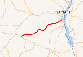
The road starts near Blue Springs at SR 10. The road has no major junctions, and the only junctions are minor county routes. The route goes past Bakerhill and then ends at U.S. Route 431 (US 431), the whole route is basically used as a shortcut between Clio and Blue Springs to the major town of Eufaula.[2]
Major intersections
The entire route is in Barbour County.
| Location | mi[1] | km | Destinations | Notes | |
|---|---|---|---|---|---|
| Clio | 0.000 | 0.000 | |||
| Eufaula | 27.124 | 43.652 | |||
| 1.000 mi = 1.609 km; 1.000 km = 0.621 mi | |||||
gollark: You must have copied it off the interwebs.
gollark: Ideally² we would also be able to test things like this in test subnations, but nobody seems very interested in doing that.
gollark: Troubling.
gollark: I would support a UBI which provides enough money to at least live off, if it wouldn't cause horrible inflation.
gollark: You never help friends somewhat?
References
- Alabama Department of Transportation (December 1999). "Milepost Map of Barbour County, Alabama" (PDF). Retrieved April 16, 2017.
- Google (March 20, 2017). "Overview Map of SR 131" (Map). Google Maps. Google. Retrieved March 20, 2017.
External links
![]()
This article is issued from Wikipedia. The text is licensed under Creative Commons - Attribution - Sharealike. Additional terms may apply for the media files.