Alabama State Route 100
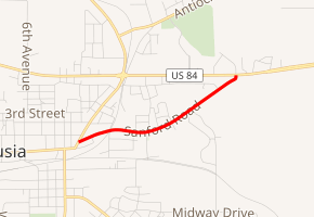
State Route 100 (SR 100) is a 1.670-mile-long (2.688 km) unsigned state highway completely within the city limits of Andalusia in Covington County. The western terminus of the highway is at an intersection with U.S. Route 29 (US 29) in the southwestern part of Andalusia. The eastern terminus of the highway is at an intersection with US 84 in the east-central part of the city.
| ||||
|---|---|---|---|---|

| ||||
| Route information | ||||
| Maintained by ALDOT | ||||
| Length | 1.670 mi[1] (2.688 km) | |||
| Existed | 1962–present | |||
| Major junctions | ||||
| West end | ||||
| East end | ||||
| Location | ||||
| Counties | Covington | |||
| Highway system | ||||
| ||||
Route description
SR 100 begins at an intersection with US 29 in the southwestern part of Andalusia. It heads east on two-lane undivided Sanford Road. The road travels through residential areas and crosses the Three Notch Railroad. The highway passes more residences before turning northeast into wooded areas. SR 100 reaches its eastern terminus at an intersection with US 84.[1][2][3]
History
SR 100 was designated in 1962 along the route of a southern bypass of Andalusia.
Until 1957, SR 100 was assigned to a road from Elm Bluff to Riley; the southern portion was replaced by the new SR 21, and the remainder was renumbered as SR 89.
Major intersections
The entire route is in Andalusia, Covington County.
| mi[1] | km | Destinations | Notes | ||
|---|---|---|---|---|---|
| 0.000 | 0.000 | Western terminus | |||
| 1.670 | 2.688 | Eastern terminus | |||
| 1.000 mi = 1.609 km; 1.000 km = 0.621 mi | |||||
See also


References
- Milepost Map (Map). Alabama Department of Transportation. Archived from the original (PDF) on July 27, 2011. Retrieved March 29, 2011.
- General Highway Map (Map). Alabama Department of Transportation. Archived from the original (PDF) on July 27, 2011. Retrieved March 29, 2011.
- Google (March 30, 2011). "overview of Alabama State Route 100" (Map). Google Maps. Google. Retrieved March 30, 2011.
