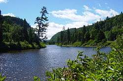
Agawa River
The Agawa River is a river in Algoma District, Ontario, Canada which empties into Agawa Bay on Lake Superior at the community of Agawa Bay, south of Wawa, Ontario.
| Agawa River | |
|---|---|
 | |
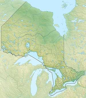 Location of the mouth of the Agawa River in Ontario. | |
| Etymology | "sheltered place" in Ojibwe |
| Native name | Aagawaa-ziibi |
| Location | |
| Country | Canada |
| Province | Ontario |
| District | Algoma |
| Physical characteristics | |
| Source | Agawa Lake |
| • coordinates | 47°50′25″N 84°14′35″W |
| • elevation | 435 m (1,427 ft) |
| Mouth | Lake Superior |
• location | Agawa Bay |
• coordinates | 47°21′05″N 84°38′14″W |
• elevation | 180 m (590 ft) |
| Basin features | |
| Tributaries | |
| • left | Little Agawa River, Eleven Mile Creek, Blackspruce Creek, Weichel Creek, Parch Creek, Regan River, Sane Creek |
History
The Agawa Rock pictographs are located on a rock face extending into Lake Superior in Agawa Bay. Some paintings are at least 1500 years old, while others may only date back to the 1800s. "Aagawaa" means "sheltered place" in the Ojibwe language.
The scenery of this region inspired a number of paintings by the Group of Seven.
Economy
The Algoma Central Railway runs an excursion train which leaves Sault Ste. Marie, Ontario and travels through the Agawa Canyon. Agawa Bay and the lower parts of the river are located in Lake Superior Provincial Park.[1]
Tributaries
- Little Agawa River
- Eleven Mile Creek
- Blackspruce Creek
- Weichel Creek
- Parch Creek
- Regan River
- Sane Creek
Settlements
- Agawa Bay
- Canyon
- O'Connor
- Eton
- Millwood
gollark: No.
gollark: True, true.
gollark: Not if your idea is fundamentally insecure!
gollark: rednet is uncool.
gollark: * modem, not rednet
See also
- List of Ontario rivers
References
- "Lake Superior". Ontario Parks. 2004-08-17. Archived from the original on 30 May 2010. Retrieved 2010-06-13.
- "Agawa River". Geographical Names Data Base. Natural Resources Canada. Retrieved 2010-06-13.
- "Toporama - Topographic Map Sheets 41N7, 41N8, 41N9, 41N10, 41N16". Atlas of Canada. Natural Resources Canada. Archived from the original on 2010-02-10. Retrieved 2010-06-13.
This article is issued from Wikipedia. The text is licensed under Creative Commons - Attribution - Sharealike. Additional terms may apply for the media files.