Abtsdorfer See
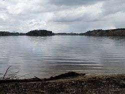
Abtsdorfer See is a lake in the region of Rupertiwinkel in Bavaria, Germany. At an elevation of 426.20 m, its surface area is 0.84 km².
| Abtsdorfer See | |
|---|---|
 | |
| Location | Bavaria |
| Coordinates | 47°54′38″N 12°54′28″E |
| Primary inflows | Weidmoosgraben, Gaberlbach, Roßgraben, Badhäuslgraben |
| Primary outflows | Schinderbach (northeast) |
| Catchment area | 21.30 km2 (8.22 sq mi) |
| Basin countries | Germany |
| Max. length | 1,568 m (5,144 ft) |
| Max. width | 968 m (3,176 ft) |
| Surface area | 0.84 km2 (0.32 sq mi) |
| Average depth | 11.25 m (36.9 ft) |
| Max. depth | 20 m (66 ft) |
| Water volume | 9,423,000 m3 (332,800,000 cu ft) |
| Shore length1 | 4.18 km (2.60 mi) |
| Surface elevation | 426.20 m (1,398.3 ft) |
| Islands | one island (Burgstall) |
| 1 Shore length is not a well-defined measure. | |
Sources
- Nixdorf, B.; et al. (2004), "Abtsdorfer See", Dokumentation von Zustand und Entwicklung der wichtigsten Seen Deutschlands (in German), Berlin: Umweltbundesamt, p. 6
gollark: I'd assume that with an entire planet worth of mass you could get at least through the... surface bit?
gollark: I don't know exactly, but I think that's true for most sensible definitions of it.
gollark: If you're within 1m of a laser, you might be blinded but might be fine. If you're within 1m of the sun, you will immediately cease to meaningfully exist.
gollark: It's MUCH more dangerous than any human laser technology.
gollark: I like to remain safe from laser videos by wearing sunglasses, which are known to provide good laser protection.
This article is issued from Wikipedia. The text is licensed under Creative Commons - Attribution - Sharealike. Additional terms may apply for the media files.