Abras, Corozal, Puerto Rico
Abras is a barrio in the municipality of Corozal, Puerto Rico. Its population in 2010 was 2,262.[3][4][5]
Abras | |
|---|---|
Barrio | |
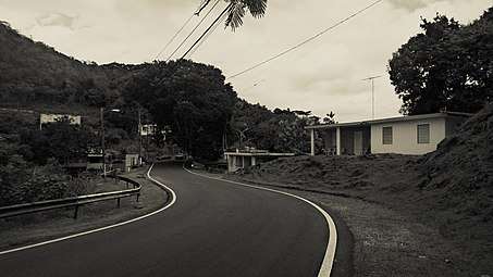 Puerto Rico Highway 821 in Abras | |
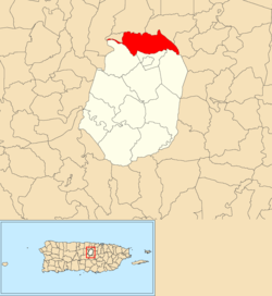 Location of Abras within the municipality of Corozal shown in red | |
 Abras Location of Puerto Rico | |
| Coordinates: 18°21′21″N 66°18′48″W[1] | |
| Commonwealth | |
| Municipality | |
| Area | |
| • Total | 3.8 sq mi (10 km2) |
| • Land | 3.8 sq mi (10 km2) |
| • Water | 0 sq mi (0 km2) |
| Elevation | 581 ft (177 m) |
| Population (2010) | |
| • Total | 2,262 |
| • Density | 595.3/sq mi (229.8/km2) |
| Source: 2010 Census | |
| Time zone | UTC−4 (AST) |
History
The United States took control of Puerto Rico from Spain in the aftermath of the Spanish-American War under the terms of the Treaty of Paris of 1898 and conducted its first census of Puerto Rico finding that the population of Abras barrio was 1,183.[6]
Sectors
Barrios (which are like minor civil divisions)[7] in turn are further subdivided into smaller local populated place areas/units called sectores (sectors in English). The types of sectores may vary, from normally sector to urbanización to reparto to barriada to residencial, among others.[8][9][10]
The following sectors are in Abras barrio:[11]
Abras
Sector Cueva de Paca, Sector El Brillante, Sector Hoya Ranch, Sector La Alcoba, Sector La Calabaza, Sector La Pollera, Sector Los Ramos, Sector Los Torres, Sector Marcelo Rosado, Sector Parcelas, Sector Víctor Pantojas, Urbanización Vista del Río I, Urbanización Vista del Río II, and Urbanización Vista del Río III.
Abras Centro
Sector Carretera (from La Capilla to Sector Sandoval), Sector Chago Adorno, Sector Charol, Sector El Convento, Sector La Capilla, Sector La Escuelita, Sector Lorenzo Agosto, Sector Los Bruno, and Sector Sandoval.
Abras Mavilla
Sector Adolfa, Sector Balalaika, Sector El Batey, Sector Los Bruno, Sector Los Mudos, Sector Los Rolones, Sector Los Rosado, Sector Los Torres, Urbanización Jardines de Mavilla, Urbanización Las Brisas, Urbanización Quintas de Plaza Aquarium, and Urbanización San Rafael.
Mavilla Bridge
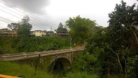
A bridge listed on the National Register of Historic Places in Puerto Rico is between Abras barrio and Palmarejo barrio, also in Corozal.[12]
References
- "US Gazetteer 2019". US Census. US Government.
- U.S. Geological Survey Geographic Names Information System: Abras barrio
- Picó, Rafael; Buitrago de Santiago, Zayda; Berrios, Hector H. Nueva geografía de Puerto Rico: física, económica, y social, por Rafael Picó. Con la colaboración de Zayda Buitrago de Santiago y Héctor H. Berrios. San Juan Editorial Universitaria, Universidad de Puerto Rico,1969.
- Gwillim Law (20 May 2015). Administrative Subdivisions of Countries: A Comprehensive World Reference, 1900 through 1998. McFarland. p. 300. ISBN 978-1-4766-0447-3. Retrieved 25 December 2018.
- Puerto Rico:2010:population and housing unit counts.pdf (PDF). U.S. Dept. of Commerce, Economics and Statistics Administration, U.S. Census Bureau. 2010.
- Joseph Prentiss Sanger; Henry Gannett; Walter Francis Willcox (1900). Informe sobre el censo de Puerto Rico, 1899, United States. War Dept. Porto Rico Census Office (in Spanish). Imprenta del gobierno. p. 161.
- "US Census Barrio-Pueblo definition". factfinder.com. US Census. Archived from the original on 13 May 2017. Retrieved 5 January 2019.
- "Agencia: Oficina del Coordinador General para el Financiamiento Socioeconómico y la Autogestión (Proposed 2016 Budget)". Puerto Rico Budgets (in Spanish). Retrieved 28 June 2019.
- Rivera Quintero, Marcia (2014), El vuelo de la esperanza: Proyecto de las Comunidades Especiales Puerto Rico, 1997-2004 (first ed.), San Juan, Puerto Rico Fundación Sila M. Calderón, ISBN 978-0-9820806-1-0
- "Leyes del 2001". Lex Juris Puerto Rico (in Spanish). Retrieved 24 June 2020.
- "PRECINTO ELECTORAL COROZAL 072" (PDF). Comisión Estatal de Elecciones (in Spanish). PR Government. 21 September 2019. Retrieved 24 June 2020.
- "National Register of Historic Places Inventory/Nomination: Mavilla Bridge". National Park Service. Retrieved June 2, 2019. With accompanying pictures