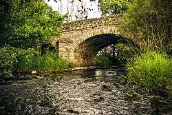
Aar (Dill)
Aar is a river of Hesse, Germany. It flows for 20.6 kilometres (12.8 mi) into the Dill near Herborn.[1]
| Aar | |
|---|---|
 | |
| Location | |
| Country | Germany |
| State | Hesse |
| Physical characteristics | |
| Mouth | |
• location | Dill |
• coordinates | 50.6977°N 8.3079°E |
| Length | 20.6 km (12.8 mi) |
| Basin features | |
| Progression | Dill→ Lahn→ Rhine→ North Sea |
Tributaries
The tributaries of the Aar are as follows:[1]
- Brühlsbach (right) - 3.3 km
- Stadterbach (left) - 6.6 km
- Wilsbach (right) - 6.3 km
- Weidbach (right) - 5.9 km
- Meerbach (right) - 5.2 km
- Siegbach (right) - 12.2 km
- Gellenbach (left) - 4.2 km
- Weibach (right) - 6.3 km
- Gettenbach (left) - 3.6 km
- Ballersbach (left) - 3.2 km
- Essenbach (right) - 3.3 km
- Dernbach (left) - 2.7 km
- Monzenbach (right) - 4.5 km
gollark: The precise time is tunable, after some amount of time it would probably cease to be discussed. And why should they *not* exist? The logreading issue is fixable as I said, search... maybe less so, but I'm not sure how many search queries actually turn up that stuff *now* and how big an issue it would be.
gollark: For logreading, it could probably put in a divider of some kind.
gollark: It could be semiautomated based on keywords (or, indeed, the criteria used to decide whether to have a conversation or not under your proposal), and disable it after, say, 15 minutes of no activity.
gollark: So, not working.
gollark: It didn't isolate all the NSFW stuff and it is dead now.
See also
References
- "WRRL Viewer". Water map service of the Hessian Ministry for the Environment, Climate Protection, Agriculture and Consumer Protection. Retrieved 8 July 2020.
This article is issued from Wikipedia. The text is licensed under Creative Commons - Attribution - Sharealike. Additional terms may apply for the media files.