Aalburg
Aalburg (![]()
Aalburg | |
|---|---|
Former municipality | |
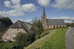 Church in Aalburg | |
 Flag Coat of arms | |
.svg.png) Location in North Brabant | |
| Coordinates: 51°46′N 5°8′E | |
| Country | Netherlands |
| Province | North Brabant |
| Established | 1973 |
| Government | |
| • Body | Municipal council |
| • Mayor | Fons Naterop (CDA) |
| Area | |
| • Total | 53.17 km2 (20.53 sq mi) |
| • Land | 50.41 km2 (19.46 sq mi) |
| • Water | 2.76 km2 (1.07 sq mi) |
| Elevation | 3 m (10 ft) |
| Time zone | UTC+1 (CET) |
| • Summer (DST) | UTC+2 (CEST) |
| Postcode | 4260–4269 |
| Area code | 0416 |
| Website | www |
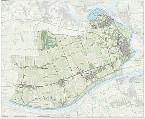
Topographic map of Aalburg, June 2015
Population centres
- Babyloniënbroek
- Drongelen
- Eethen
- Genderen
- Meeuwen
- Veen
- Wijk en Aalburg (town hall)
Sport
Cycling
Aalburg host annually the 7-Dorpenomloop Aalburg, an elite women's road bicycle race since 2007.
gollark: Unless you subcontract to other people to hold gusties until they hit ultra low time, you'll be bottlenecked by that.
gollark: 216000, 10, what's the difference?
gollark: Or use the Ap, which is lower-time.
gollark: Perhaps it is actually time-based, with chances being great on some days and awful on others.
gollark: or something like that.
References
- "Burgemeester" [Mayor] (in Dutch). Gemeente Aalburg. Archived from the original on 2014-04-24. Retrieved 22 April 2014.
- "Kerncijfers wijken en buurten" [Key figures for neighbourhoods]. CBS Statline (in Dutch). CBS. 2 July 2013. Retrieved 12 March 2014.
- "Postcodetool for 4261BE". Actueel Hoogtebestand Nederland (in Dutch). Het Waterschapshuis. Archived from the original on 21 September 2013. Retrieved 24 April 2014.
- Ad van der Meer and Onno Boonstra, Repertorium van Nederlandse gemeenten, KNAW, 2011.
External links

- Official website
Places adjacent to Aalburg | |
|---|---|
This article is issued from Wikipedia. The text is licensed under Creative Commons - Attribution - Sharealike. Additional terms may apply for the media files.