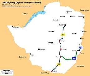
A10 road (Zimbabwe)
The A10 Highway is a primary road that runs from Ngundu in south Masvingo Province to Tanganda through the Mutare-Masvingo Highway in Manicaland Province.[1][2]
| A10 road | |
|---|---|
 | |
| Highway system | |
| Transport in Zimbabwe |
Background
The A10 Highway also called the P5 Highway[3] begins at where Cashel/Chimanimani Road turns off from the A9 Highway which runs from Mutare to Masvingo19°30′22″S 32°31′51″E. It ends at Ngundu in Masvingo Province where it makes a T-junction with the A4 Highway running from Harare to Beitbridge. 20°47′41″S 30°48′01″E
Locals in Manicaland like to call it Chimanimani Road and after Chimanimani Turn of they call it Tanganda Road and further on they call it Chiredzi Road. Those around Ngundu call it Chiredzi Road and past Chiredzi turn-off they call it Save Road, Tanganda Road and finally Mutare Road.
Junctions
(Direction: North to South.)
- Cashel Turn-off. Cashel Road continues straight ahead while A10 turns right. 19°31′51″S 32°38′45″E
- Chimanimani Turn-off. Chimanimani Road proper turns left here. 19°52′55″S 32°44′19″E
- Chipinga Turn-off. Here the road straight ahead is to Chipinga which is the A16 Highway.
The A10 Highway turns right to merge with the A16 Highway. 20°05′14″S 32°38′49″E
- Tanganda Turn-off. Here the A10 Highway turns sharp left from the merge with the A16 Highway. The A16 continues straight on for 22.3 km to the junction with the A9 Highway east of Birchenough Bridge.
Major Bridges
- Save River. 20°59′56″S 32°09′29″E
- Mutirikwi River. 21°02′32″S 31°23′26″E
- Chiredzi River. 21°00′44″S 31°44′54″E
Toll Gates
The road is tolled at Toll Plaza number "35" between the 70.5-71.5 km peg, 9 km before Triangle.[5][6]
See also
- A4 Highway
- A9 Highway
- A16 Highway
- ZINARA
- Transport in Zimbabwe
References
- Google Maps |Static Map Centre -19.990568,30.995527 maps.googleapis.com|Maps|Retrieved 20 April 2016
- Google Maps |Static Map Center -20.188929,32.619423 maps.googleapis.com|Maps|Retrieved 20 April 2016
- African Development Bank|Chapter 9: Road Transport Services and Infrastructure- African: Map 9.2 African Development Bank|Documents|Retrieved 13 April 2016
- Directions |Ngundu to Chiredzi 108 km (67.00 miles) |Ngundu, Zimbabwe 108 km. (About 1 hour 22 mins) 1. Head east on A10 105 km 2. Turn right onto Inyati Dr 1.6 km 3. Turn left onto Lion Dr 0.9 km 4. Turn left onto West Rd Destination will be on the left 0.5 km Chiredzi, Zimbabwe Distance Monk|Ngundu to Chiredzi|Retrieved 19 April 2016
- Big SK. 7 December 2011 Archived 2016-04-27 at the Wayback Machine Bigsky.co.zw |Blog|Retrieved 21 April 2016
- Eng. Moses Julius Juma. 23 February 2015 | UPDATED_Armfa_Feb_2015 | Page 52. Map showing future tolling points to be put up by end of year 2015 Archived 2016-04-20 at the Wayback Machine armfa.net| Retrieved 21 April 2016