37th meridian west from Washington
The 37th meridian west from Washington is an archaic meridian based on the Washington meridian. It is currently located at approximately 114 degrees, 3 minutes west of the Greenwich meridian.[1] The meridian is used as a boundary for two states.
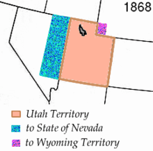
The territorial change which created the boundary usage of the meridian
Usage as a boundary
The first and only usage of the meridian as a boundary occurred in 1866. In that year, the state of Nevada's eastern boundary was pushed one degree further east to the current boundary.[2] This also had the effect of pushing the Utah Territory's western boundary further east. Utah would become a state in 1896.[3]
gollark: Also, you should contribute the thing back to open source such that future people will be able to build on your thing.
gollark: Just use your thing on itself an arbitrary number of times.
gollark: It seems like it's able to beat zstd and brotli a bit on that input, although I haven't checked if it actually decompresses right.
gollark: It *does* seem like it could be quite good if not optimized for hypermicrosizes of the decompressor.
gollark: Never mind, zstd gets similar ratios, seems plausible.
References
- Stein, Mark (2008). How the States Got Their Shapes. New York: Smithsonian Books. p. 176. ISBN 978-0-06-143138-8.
- 14 Stat. 43
- Rood, Ron; Thatcher, Linda (2014). "A Brief History of Utah: Statehood". Utah History to Go. State of Utah. Retrieved 16 May 2014.
This article is issued from Wikipedia. The text is licensed under Creative Commons - Attribution - Sharealike. Additional terms may apply for the media files.