Øverlandselva
Øverlandselva is a river that flows through Bærum, Norway.
| Øverlandselva Øverlandselven | |
|---|---|
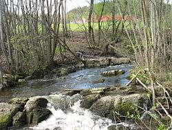 Øverlandselva with Øverland in the background. | |
| Etymology | Øverland farm |
| Location | |
| Country | Norway |
| Region | Eastern Norway |
| District | Viken |
| Municipality | Bærum |
| Physical characteristics | |
| Source | |
| • location | Øverland, Bærum, Norway |
| • coordinates | 59.9404°N 10.5707°E |
| Mouth | Engervannet |
• location | Blommenholm, Bærum, Norway |
• coordinates | 59.8990°N 10.5393°E |
• elevation | 4 m (13 ft) |
| Basin features | |
| River system | Sandviksvassdraget |
It starts near Øverland in northern Bærum, at the confluence of the creeks Seternbekken and Ilabekken. It runs south and southwest, emptying into the eastern side of Engervannet at Blommenholm. A river runs from Engervannet and flows into Sandvikselva, but this portion is called Rønneelva.[1]
References
- Bakken, Tor Chr., ed. (2008). "Øverlandselva". Budstikkas store Asker og Bærum-leksikon (in Norwegian). Oslo: Kunnskapsforlaget. p. 499. ISBN 978-82-573-1534-4.
This article is issued from Wikipedia. The text is licensed under Creative Commons - Attribution - Sharealike. Additional terms may apply for the media files.