Öfnerspitze
The Öfnerspitze is a 2,576 m (2,575 m in Austrian maps) high, rocky mountain in the Allgäu Alps.
| Öfnerspitze | |
|---|---|
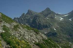 The Krottenspitze and Öfnerspitze from the Kratzer | |
| Highest point | |
| Elevation | 2,576 m above sea level (8,451 ft) |
| Prominence | 133 m ↓ Marchergang → Großer Krottenkopf |
| Isolation | 0.6 km → Großer Krottenkopf |
| Coordinates | 47°19′03″N 10°20′56″E |
| Geography | |
| Parent range | Hornbach chain, Allgäu Alps |
| Geology | |
| Mountain type | Main Dolomite |
| Climbing | |
| First ascent | during an 1854 survey |
Location and area
The Öfnerspitze lies southeast of the Krottenspitze and is joined to it by a flat saddle.
Ascent
There are no marked trails to the Öfnerspitze. The easiest approach branches off the path to the Muttlerkopf and is partly marked by cairns and difficult to find. It requires sure-footedness and experience in navigating through trackless terrain. For this reason the Öfnerspitze is relatively rarely climbed; in addition the nearby Großer Krottenkopf is higher and has a view that is just majestic if not more so.
Sources
- Thaddäus Steiner: Allgäuer Bergnamen, Lindenberg, Kunstverlag Josef Fink, 2007, ISBN 978-3-89870-389-5
- Thaddäus Steiner: Die Flurnamen der Gemeinde Oberstdorf im Allgäu, Munich, Selbstverlag des Verbandes für Flurnamenforschung in Bayern, 1972
- Zettler/Groth: Alpenvereinsführer Allgäuer Alpen. Munich, Bergverlag Rudolf Rother 1984. ISBN 3-7633-1111-4
gollark: Also C.
gollark: You know what else runs on a lot of architectures now? WebAssembly.
gollark: oh no.
gollark: You do get people who aren't very good at CC/programming/whatever but are at least willing to learn and not be incredibly annoying, which is good.
gollark: But sometimes you get LukeOS guy.
External links
| Wikimedia Commons has media related to Öfnerspitze. |
This article is issued from Wikipedia. The text is licensed under Creative Commons - Attribution - Sharealike. Additional terms may apply for the media files.