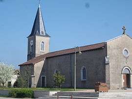
Étrez
Étrez is a former commune in the Ain department in eastern France. On 1 January 2019, it was merged into the new commune of Bresse Vallons.[2]
Étrez | |
|---|---|
Part of Bresse Vallons | |
 | |
Location of Étrez 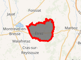
| |
 Étrez  Étrez | |
| Coordinates: 46°20′06″N 5°11′08″E | |
| Country | France |
| Region | Auvergne-Rhône-Alpes |
| Department | Ain |
| Arrondissement | Bourg-en-Bresse |
| Canton | Attignat |
| Commune | Bresse Vallons |
| Area 1 | 12.15 km2 (4.69 sq mi) |
| Population (2017)[1] | 811 |
| • Density | 67/km2 (170/sq mi) |
| Time zone | UTC+01:00 (CET) |
| • Summer (DST) | UTC+02:00 (CEST) |
| Postal code | 01100 |
| Elevation | 197–229 m (646–751 ft) |
| 1 French Land Register data, which excludes lakes, ponds, glaciers > 1 km2 (0.386 sq mi or 247 acres) and river estuaries. | |
Population
| Year | Pop. | ±% |
|---|---|---|
| 1793 | 494 | — |
| 1800 | 400 | −19.0% |
| 1806 | 489 | +22.2% |
| 1821 | 518 | +5.9% |
| 1831 | 533 | +2.9% |
| 1836 | 531 | −0.4% |
| 1841 | 505 | −4.9% |
| 1846 | 503 | −0.4% |
| 1851 | 512 | +1.8% |
| 1856 | 786 | +53.5% |
| 1861 | 530 | −32.6% |
| 1866 | 576 | +8.7% |
| 1872 | 570 | −1.0% |
| 1876 | 643 | +12.8% |
| 1881 | 623 | −3.1% |
| 1886 | 620 | −0.5% |
| 1891 | 603 | −2.7% |
| 1896 | 595 | −1.3% |
| 1901 | 595 | +0.0% |
| 1906 | 604 | +1.5% |
| 1911 | 570 | −5.6% |
| 1921 | 532 | −6.7% |
| 1926 | 554 | +4.1% |
| 1931 | 505 | −8.8% |
| 1936 | 487 | −3.6% |
| 1946 | 498 | +2.3% |
| 1954 | 445 | −10.6% |
| 1962 | 429 | −3.6% |
| 1968 | 398 | −7.2% |
| 1975 | 398 | +0.0% |
| 1982 | 505 | +26.9% |
| 1990 | 510 | +1.0% |
| 1999 | 642 | +25.9% |
| 2008 | 801 | +24.8% |
| 2015 | 820 | +2.4% |
gollark: You could just make the function contain... its argument names and content, surely?
gollark: (number)
gollark: 1.0000000004
gollark: Wait, is this just osmarkslisp™ with slightly different brackets?
gollark: `let` good, as they say.
See also
This article is issued from Wikipedia. The text is licensed under Creative Commons - Attribution - Sharealike. Additional terms may apply for the media files.