What's the best software for geotagging photos and publishing them?

0

2

I recently bought a GPS logger for geotagging my phtotos. Ultimately, I'd like to create holiday/trip journals for friends and relatives where individual entries, together with photos, accessible via a map.

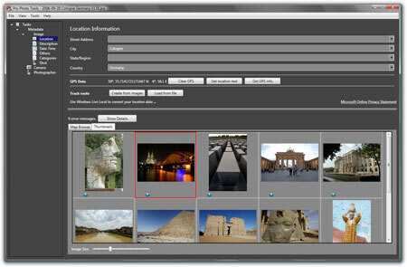
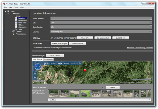
  1. What's the best software for the geotagging? I've tried locr and GPS-Track-Analyse.NET, but I'm mainly missing a feature that allows me to easily find the right clock adjustment. Ideally, I'd like to be able to visually select the exact spot on the map where I took one photo and have the geotagging of all photos adjusted to match.
  2. What's the best way to publish GPS tracks and photos in journal format? TripTracker looks pretty good for an online service - is there something similar that I could run on my own server (would have to be PHP-based)? Another interesting alternative would be something that produces a self-contained KMZ file for use in Google Earth - PhotoKML is great for the photos, but there should also be a title displayed with the thumbnails (which themselves are nice but not necessary), a journal entry when you click on them, and ideally also the GPS track.

Edit: I'd prefer free software, though a modest price tag (up to about $50) would be acceptable for something with compelling features; I'm using Windows XP.

Michael Borgwardt

Posted 2009-07-28T08:44:45.930

Reputation: 3 047

Question was closed 2012-08-25T07:17:58.923

What OS are you using? And should it be free? – Ivo Flipse – 2009-07-28T08:46:37.953

Define "best" otherwise anything can be "best" – random – 2009-07-28T08:47:57.250

I've described the features I'm looking for, and I'm open to suggestions, being relatively inexperienced and not knowing exactly what features are particularly important or useful. Yes, "best" is subjective, but any answer that includes arguments why someone considers a particular program "best" is useful - arguments about semantics are not. – Michael Borgwardt – 2009-07-28T08:55:53.473

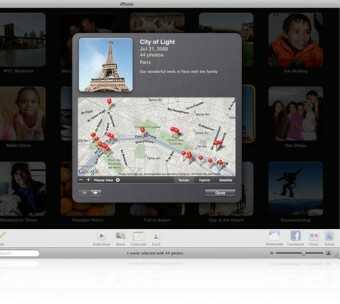
iPhoto has a nice geotagging feature called Places. Comes free with a Mac. But a Mac costs more than $50. So I guess it's out of the question for you. ;-) – GeneQ – 2009-07-28T08:56:09.650

1SU isn't a product review/recommendation service. – random – 2009-07-28T08:58:30.427

Yes, it is. Read the FAQ. – Michael Borgwardt – 2009-07-28T09:08:59.873

Answers

3

Perhaps try Microsoft Professional Photography

I think it works with their AviSynth service as well

for Mac try Geophoto

What does it mean to say, "Find your photos?" Traditionally that meant literally just finding where particular photos reside on your computer (or a physical location back when film was king). But with new tools and advanced technology, finding your photos can mean finding not just the photos themselves, but finding the exact location where you took a photo. This, in turn, will make it even easier to search for the photos themselves later. Microsoft Pro Photo Tools enables you to apply location information to your photos so you can always know exactly where they were captured.

alt text

To add GPS coordinate information to your photos:

Open your photos in Pro Photo Tools.

Go to the Location section under Tasks Metadata > Image on the left panel.

Select all images by pressing Ctrl+A, and then click the Load from File button under Track Route.

Click the Place Images button under Track Route and the images will be placed on the map.

You can fine-tune the position using the slider controls below the map. When the images are in the correct position along the track route, click Done, and the GPS coordinates will be added to your photos based on the time stamps in the track route file.

alt text

Ivo Flipse

Posted 2009-07-28T08:44:45.930

Reputation: 24 054

Sweet! Exactly what I was looking for! – Michael Borgwardt – 2009-07-28T09:07:56.103

2

"first you have to explicitly allow picasa to use the gps-information inside the EXIF-data of the images. You have to go to "Settings" and then activate "Use Exif location information." Normally, as soon as Picasa discovers images with location tags, it will ask you if you want to enable this function. "

jan

Posted 2009-07-28T08:44:45.930

Reputation: 291

What will the result be? – Michael Borgwardt – 2009-07-28T16:25:55.987

1In Picasa itself, nothing spectacular in fact, just an icon "Geotagged". You can view them with Google Earth, or, you can upload them to a Picasa web album which will then show a map/satellite/terrain with the pictures pinned on. – jan – 2009-07-29T08:40:09.077

1

I'm obviously biased, as I wrote it myself, but I'd suggest you to take a look at Mappero Geotagger.
It's open source and runs on Linux, OS X and Windows. Packaged versions for Ubuntu, OS X and Windows can be purchased from its website.

Mardy

Posted 2009-07-28T08:44:45.930

Reputation: 11

Wrote an email to the author of Mappero Geotagger, didn't get a reply. Downloaded the source code, built and tried to run, it crashes. – David V. – 2015-08-10T13:21:41.247

0

Chris Marquardt recently talked about geotagging on his TFTTF 367 podcast (from 21 minutes onward), and there's some discussion on the show notes page I've linked to. No experience with this myself but hope it helps.

Alistair Knock

Posted 2009-07-28T08:44:45.930

Reputation: 834

0

The latest iPhoto places feature does this very well if you are using a mac.

iPhoto

Bruce McLeod

Posted 2009-07-28T08:44:45.930

Reputation: 5 490

0

Concerning the publishing, I found this site with a direct comparison of web galleries with maps (Flickr, Picasa, locr and EveryTrail). Of these, I found Picasa's interface most pleasant to use.

However, I've also found that Google Maps can display KMZ files directky - including embedded images and HTML markup. That, embedded in my own webpage is just about perfect for my needs, especially since it would allow me to prepare everything offline and then upload it in one go rather than having to use a web interface for an extended period of time, which can be difficult during travels.

Michael Borgwardt

Posted 2009-07-28T08:44:45.930

Reputation: 3 047