Burt's solar compass
Burt's solar compass is a surveying instrument that makes use of the sun's direction instead of magnetism. William Austin Burt invented his solar compass in 1835. The solar compass works on the principle that the direction to the sun at a specified time can be calculated if the position of the observer on the surface of the Earth is known, to a similar precision. The direction can be described in terms of the angle of the sun relative to the axis of rotation of the planet.

This angle is made up of the angle due to latitude, combined with the angle due to the season, and the angle due to the time of day. These angles are set on the compass for a chosen time of day, the compass base is set up level using the spirit levels provided, and then the sights are aligned with the sun at the specified time, so the image of the sun is projected onto the cross grating target. At this point the compass base will be aligned true north-south. It is then locked in place in this alignment, after which the sighting arms can be rotated to align with any landmark or beacon, and the direction can be read off the verniers as an angle relative to true north.[1]
The reason for using this instrument was to get away from the erratic readings of a normal magnetic compass when in a locality of high iron ore content and inconsistent and unknown local magnetic variation. The instrument was found to be so accurate that it was the choice of the United States government when surveying public lands, state boundaries, and railroad routes. It won awards from various organizations for its technology as being simple, rugged, inexpensive, reliable and accurate. It was used by surveyors from the nineteenth century into the twentieth century.
History of Burt compass
Burt became a United States deputy surveyor in 1833 and began surveying government land for a territory northwest of the Ohio River.[2] He and his surveying crew by 1834 were surveying territory in the lower peninsula of Michigan. He was surveying land in the upper peninsula of Michigan by 1835 to be used by new settlers.[3] Here he found that his sensitive magnetic needle compass was fluctuating all over the place. This was being caused by the iron ore deposits in the area. Burt then devised an instrument attachment that worked off sunlight, not magnetism, to find true north. He called the resulting product a True Meridian Finding instrument.[4] It got away from the vagaries of the magnetic compass caused by iron ore deposits in a local land mass district.[5]
Burt first used the solar instrument in his Michigan surveys.[6] He found large outcropping deposits of iron ore at Negaunee in Marquette County in his later 1844 survey of the upper peninsula of the state of Michigan.[7] This would become known as the Marquette Iron Range.[8] His crew found small deposits of iron ore in the state's lower peninsula at about the same time.[9] Because of his accidental discovery of these iron deposits in Michigan he contributed much to America's Industrial Revolution.[10] The Calumet and Hecla Mine of Michigan's Copper Country was the leading copper producer in the world and discovered with Burt's instrument.[11]
Burt's solar compass uses the location of the sun with astronomical tables and enables surveyors to run more accurate lines, saving the surveyor much time. Burt had a model of his instrument built in 1835 by William James Young, a professional instrument maker.[12] He then submitted this solar compass to a committee at the Franklin Institute in Philadelphia.[13] They examined its characteristics and then awarded Burt twenty dollars in gold and the John Scott Medal for its technology.[14] It was patented February 25, 1836.[6] It has since been referred to as Burt's Solar Compass or Astronomical Compass. He used it in late 1836 to survey the Fifth Principal Meridian in Iowa.[15] Burt improved on the instrument over the years and in 1840 he received another patent on his solar compass.[16] He resubmitted the updated version of the instrument to the Franklin Institute where they found it to be more accurate and easier to use than the first version.[13] Cincinnati Land Office general surveyor E. S. Haines examined Burt's surveying instrument in December of 1840 and reported in a 1841 letter that with its' four year experience in surveying it was found to be superior in technology to the normal magnetic compass then used by most surveyors.[17] The Commissioner of the Federal Land Office sent letters to Surveyor Generals throughout the United States saying Burt's compass was being manufactured by the surveyor Henry Ware and available for purchase.[15]
Renown surveyor Bela Hubbard noted in 1845 that with Burt's solar compass they could survey a straight line through iron rich country, where it would be an impossible task using the normal magnetic compass.[18] The instrument was widely adopted for surveying land in the United States and from the mid nineteenth century until well into the twentieth century it was mandatory for government surveying.[19] Its original impetus was for use where the old fashion magnetic style compass was vulnerable to large land iron deposits that made unusable readings. It was then found to be superior in general to the magnetic compass even when local iron ore deposits were not a problem. A solar compass attachment to the surveyor's transit, was still the recommended method to use for obtaining the true north direction as instructed in the 1973 surveyor's manual of the US Bureau of Land Management.
Burt's instrument invented in 1835 was used to survey 75 per cent of the public lands of the United States, consisting of nearly a billion acres.[20] It had saved the government millions of dollars because of its general inexpensive price tag and the accuracy of the survey. It was vital in surveying mineral lands in many states including Michigan, Wisconsin, Minnesota, Arkansas, and Colorado.[21] Its project expenditure to survey a section of land was only a fraction of what it used to cost before his invention. An example of comparison was the boundary line between Iowa and Minnesota that was surveyed before at $120 a mile with the use of the old fashion instruments, while with Burt's solar compass it was only $15 per mile.[22]
Burt patented his solar compass innovation on February 25, 1836.[23] He used it during two seasons, 1836–1837 and 1842–1843, surveying land in Iowa.[24] When his solar compass original patent of 1835 was about to expire, he went to Washington with his son to apply for a renewal in 1849.[20] The land commissioner committee, who consisted of senators from Michigan and other states, recognizing the value of Burt's solar compass in public land surveys, persuaded him to forego renewal and petition congress for suitable advance compensation. Burt did as was suggested to him on the faith he would get paid for his patent of such a valuable instrument. However the compensation indicated did not materialize in Burt's lifetime or at any time thereafter.[20] Since there was no patent on Burt's solar compass after 1850, instrument makers manufactured and sold "Burt's solar compass" to surveyors as a commercial product.[25] The inventor spent thousands of dollars to perfect his instrument, but only received back eighty dollars in compensation for his labors.[20]
In the preface to his Key to Solar Compass and Surveyor's Companion published in 1858 by his associate William S. Young, Burt refers to the many requests for such a book on how to use his solar compass. He explains a magnetic compass had problems with the true meridian at different localities. It also had problems from day to day with different readings from that expected as a constant or from previous readings. It was determined that a magnetic compass used as a surveying tool was interfered many times from the local attraction of iron ore making it inaccurate.[20] A much better guide for the surveyor than the magnetic needle compass was desired. Burt's diligent hard work, persistence and perseverance ultimately paid off in the invention of the Solar or Astronomical Compass.[26]
Description of Burt's solar compass
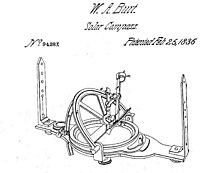
from 1836 US patent documentation.
Principle of operation
Surveyors can locate true north by viewing the sun or other astronomical object like stars or the moon, which have a direction from any given point on the surface of the Earth which can be calculated precisely for a given date and time, and which is not influenced by local variations in the magnetic field due to local deposits of minerals such as iron ore.
Burt's instrument allows surveyors to determine the true north direction by reference to the sun rather than being influenced by the earth's magnetic field.[16] It is made of brass and therefore has no magnetic influence on a compass needie, [16] as it was originally a small attachment to a standard surveyor's magnetic compass.[27]
To understand the functions of the parts of the solar compass, it is necessary to understand the apparent motion of the sun around the earth, relative to the earth as the center of the frame of reference, and more specifically, relative to the position of the instrument when set up to use in a survey. An understanding of the latitudinal and seasonal declination, and longitudinal variation with time of day are necessary, as the compass has specific sub-assemblies to take each of these variables into account.
At the Earth's equator during the equinoxes, the sun has no seasonal declination, and rises due east, and sets due west. At noon the sun is at the highest point, directly overhead and in the lowest point at midnight, and appears to move in the plane of the equator.[28][29] At locations away from the equator, the noon altitude of the sun will be reduced by the angle of the earth's local horizontal to the polar axis – the latitude – so at a latitude of 10° south or north, the noon altitude will be 90°-10°=80° at the equinoxes. This angle is known to the surveyor, and is set on the latitude arc of the instrument, so that with the base leveled, and the compass aligned with true north, the axis of the hour arc will be parallel to the polar axis.
The rotational axis of the earth is tilted from the perpendicular to the plane of its orbit around the sun. This angle causes the altitude angle of the sun to vary with the seasons, by an amount which depends on the direction of the misalignment, and which varies predictably throughout the year, increasing and decreasing smoothly at a calculable rate, and is constant for everywhere on earth at the same time. This value is also known to the surveyor, as it is published in a set of tables in an almanac. A correction for this declination is made on the declination arc of the compass, which is mounted to rotate on the polar axis on top of the latitude arc, as the latitude and declination angles are additive. The angle of the sun due to time of day is set on the hour angle arc, which is perpendicular to the polar axis. This angle is calculated from longitude and GMT, also tabulated for the convenience of surveyors and navigators, as the calculations are tedious to perform in the field, and any error could have extensive effects.
If a straight line were drawn from the rising sun to the setting sun, and from the sun at noon and at midnight on the equinoxes, both of these lines would pass through the Earth's center and the equator would intersect these lines. This is not so when the sun has north or south declination because its apparent motion will be at an angle to the equatorial plane, equal to the amount of the sun's declination north or south, so that when the sun has north or south declination, and the earth is regarded as the center of its revolutions, the line from the sun to the center of the earth describes a cone.[28][29]
This conical motion of the sun can also be illustrated by the dished spokes of the wheels of a covered wagon. The rim representing the sun's apparent path, the hub, the earth, and the spokes, lines drawn from the sun's path. It may be seen that a line drawn from the sun to the Earth's center would pass north or south of the equator, equal in degree to its declination north or south. The instrument has an equatorial movement, with a It also has a mechanical attachment for sighting a star as a reference.[28][29]
Construction of a typical model

Burt's solar compass consists of a main plate mounted to the tripod stand and leveled using the two orthogonal attached spirit levels. It carries a magnetic compass needle box, having divisions for the north end of the needle of about 36 degrees, with a vernier to read the needle's variation, and the three adjustable arcs of the solar instrument: one is set for the latitude of the location; another for the seasonal declination of the sun; and the third for the hour of the day adjusted for longitude of the location. The sights to set alignment by the sun are mounted on the movable arm of the declination arc and have a small lens for focusing an image of the sun's disc on the target grating. The upper plate is aligned with the sun and remains stationary after polar alignment, while bearings are taken with the sights on the lower plate. The lower plate carries the surveying sights and can be rotated relative to the upper plate, and may be clamped in any position to the upper plate.[28][29] There is a graduated ring on the lower plate which displays the relative rotation between the north-aligned top plate and the surveying sight-line on the bottom plate, and has verniers to allow precise reading of the angle. [28][29]
The latitude arc is attached perpendicular to the upper plate. The hour arc is fixed perpendicular to the movable upper part of the latitude arc, and the declination arc swivels on a polar axis over and perpendicular to the declination arc. The positions of the arcs can be finely adjusted by screws and the angles read with a vernier. Clamp screws are provided where necessary to lock the components in place. At the one end of the adjustable limb of the declination arc there are small lenses set up to focus an image of the sun's disc onto a target plate inscribed with parallel pairs of perpendicular lines to frame the image when correctly aligned.[28][29]
The operation is as follows:
- Set the sun's declination for that day, obtained by means of tables, on a scale attached perpendicular to the time arc.
- Set the latitude of the location on a scale in the alidade.
- Set the approximate local time on the arc that rotates on a polar axis.
- Orient the instrument, while it remains level, so the image of the sun appears between four scribed lines on the screen opposite to the lens. The time dial is fine adjusted to bring the image between a second pair of scribed lines perpendicular to the first pair. The main axis of the upper plate will then point to the pole.
- The pinnula (sighting vanes) may then be aligned with a terrestrial object and its bearing read from the angle scale.
- The magnetic declination may be read from a compass attached to the base plate.[28][29]
Awards
Burt improved the instrument over the years. In 1851, he exhibited his latest version at the Great Exhibition World's Fair in London.[30] There it was examined and endorsed by scholar John Herschel.[11] Burt received a prize medal award from the fair for his compass instrument design.[11][31] He then received another medal by jurors of Astronomical Instruments.[32][33]
See also
- Vegvísir – Icelandic magical stave intended as a wayfinder
- Astrocompass – Tool for finding true north through the positions of astronomical bodies
- Grid compass – A navigating instrument that facilitates steering a steady course
- Equatorial sextant – Navigational instrument
References
https://www.newspapers.com/clip/54147491/
- Burton H. Boyum (4 April 2017). "The Solar Compass of William Austin Burt: Its Principles and Practice". Retrieved 6 July 2020.
- White 1922, p. 367.
- Ashworth 1987, p. 81.
- Smart 1962, p. 23.
- Reynolds 2011, p. 16.
- White 1983, p. 96.
- Mitts, Dorothy (April 5, 1964). "Typewriter Inventor Pioneered Here". The Times. Port Huron, Michigan. p. 8 – via Newspapers.com

- "Survey traces are uncovered". The Escanaba Daily Press. Escanaba, Michigan. March 9, 1976. p. 3 – via Newspapers.com
- Hubbard 2008, p. 292.
- Rosentreter 2014, p. 188.
- Farmer 1884, p. 362.
- Burt 1873, p. 3.
- "William Austin Burt". Journal of the Franklin Institute: 97–98. 1841. Retrieved June 23, 2020.
- "The John Scott Award". University of Pennsylvania Garfield Library. Retrieved June 26, 2020.
- Stewart 1975, p. 89.
- Lamphier 2019, p. 287.
- Burt 1844, p. 26.
- Magnaghi 2017, p. 82.
- Mining and metallurgy, Issues 169-180 By American Institute of Mining and Metallurgical Engineers, p. cccxli Charles S. Burt, the grandson of William Austin Burt
- "The Solar Compass claim". Detroit Free Press. Detroit, Michigan. April 29, 1888. p. 28 – via Newspapers.com
- "The Solar Compass was invented by William Austin Burt in 1835". The Gazette. Cedar Rapids, Iowa. January 15, 1908. p. 8 – via Newspapers.com
- "The Solar Compass was invented by William Austin Burt in 1835". The Gazette. Cedar Rapids, Iowa. January 15, 1908. p. 8 – via Newspapers.com
- Ingram (2020). "1836 Solar Compass Patent". Virtual Museum of Surveying. Ingram-Hagen & Company. Retrieved June 23, 2020.
- "Replica of First Typewriter in Hands of Austin Burt, Descendant of Maker". The Courier. Waterloo, Iowa. June 17, 1922. p. 5 – via Newspapers.com
- Fuller 1922, pp. 175–183.
- Burt, Key to the Solar Compass and Surveyor's Companion preface
- Whitten, Charles A. (1977). "Theodolites and Transits". Surveying and Mapping. 37: 111. Retrieved July 1, 2020.
- Burt 1844, pp. 3-19.
- A Key to the Solar Compass, and Surveyor's Companion, pp. 9–11
- "The Great Exhibition / Official list of American Exhibitors". Daily News. London, England. January 22, 1851. p. 2 – via Newspapers.com
- "List of Awards". The Daily Republic. Washington, District of Columbia. November 5, 1851. p. 3 – via Newspapers.com
- White, p. 367
- Farmer 1889, p. 1180.
Sources
- R. A. Bagnold and W. J. Harding King, "Journeys in the Libyan Desert 1929 and 1930", The Geographical Journal, Vol. 78, No. 6 (Dec., 1931), pp. 524, 526–535
- Ashworth, William (1987). The Late, Great Lakes. Wayne State University Press. ISBN 978-0814-31887-4.
- Burt, William Austin (1844). Description of the Solar Compass with Directions for Its Adjustment and Use. Geiger & Christian. OCLC 982883490.
- Burt, William Austin (1873). A Key to Solar Compass and Surveyor's Companion. D. van Nostrand. OCLC 30003545.
- Burt, John, History of Solar Compass Invented by William A. Burt (1878).
- Fuller, George Newman (1922). Michigan history, Volume 6. Michigan Department of State. OCLC 983255566.
- Farmer, Silas (1884). History of Detroit and Michigan. S. Farmer & Company. OCLC 1130079700.
- Farmer, Silas (1889). History of Detroit & Michigan, The Metropolis Illustrated. S. Farmer & Company. OCLC 247412640.
- Hubbard, Bill (2008). American Boundaries / The Nation, States, and Rectangular Survey. ISBN 978-0226-35593-1.
- Lamphier, Peg A. (2019). Technical Innovation in American History:An Encyclopedia of Science and Technology. ABC-CLIO. ISBN 978-1610-69094-2.
- Magnaghi, Russell M. (2017). The Upper Peninsula of Michigan history. 906 Heritage. ISBN 978-1387-01681-5.
- Kuno Gross The Bagnold sun-compass, history and utilization Books on demand 2011
- Reynolds, Terry S. (2011). Iron Will - Cleveland Cliffs and Mining of Iron, 1847-2006. Wayne State University Press. ISBN 978-0814-33643-4.
- Rosentreter, Roger L. (2014). Michigan - The History of Explorers and Entrepreneurs. University of Michigan Press. ISBN 978-04720-2887-0.
- Smart, Charles E. (1962). The Makers of Surveying Instruments in America since 1700 (PDF). Martino Publishing. ISBN 978-15789-8488-6.
- Stewart, Lowell O. (1975). Public Land Surveys / History, Instructions, Methods. Wisconsin Land Surveyors Association.
- Tuttle, Charles Richard, General History of the state of Michigan with biographical sketches, R. D. S. Tyler & Co., Detroit Free Press Company, 1873
- White, C. Albert (1983). History of Rectangular Survey System. U.S. Department of the Interior, Bureau of Land Management. OCLC 29991586.CS1 maint: ref=harv (link)
- White, James T. (1922). Cyclopedia of American Biography, Volume 18. J. T. White. OCLC 164589128.CS1 maint: ref=harv (link)
- W. B. Kennedy Shaw, "Desert Navigation: Some Experiences of the Long Range Desert Group", The Geographical Journal, V.102, Number 5, 1943, pp. 253-258 Published by The Royal Geographical Society